Trail Walking Les Monts-d'Andaine - La Sauvagère - Photo
 tracegps
tracegps

User

© OpenStreetMap contributors
Length
Length
9 km
Max alt
Max alt
310 m
Uphill gradient
Uphill gradient
154 m
Km-Effort
Km-Effort  
11 km
Min alt
Min alt
216 m
Downhill gradient
Downhill gradient
152 m
Boucle
Boucle
Yes
Creation date :
2014-12-10 00:00:00.0
Updated on :
2014-12-10 00:00:00.0

(0 Reviews)

Walking
Walking
2h30
Difficulty : Medium

Scan this QR Code to open this trail in the SityTrail application

FREE GPS app for hiking

Logo SityTrail SityTrail

IGN / Geographical institutes

Download SityTrail from the App Store Download SityTrail from Google Play

Logo SityTrail SityTrail World

The world is yours!

Download SityTrail from the App Store Download SityTrail from Google Play Download SityTrail on Huawei AppGallery

About

Trail Walking of 9 km to be discovered at Normandy, Orne, Les Monts-d'Andaine. This trail is proposed by tracegps.

Description

Les petits chemins de La Sauvagère.

Elevation profile

Positioning

Country:
France
Region :
Normandy
Department/Province :
Orne
Municipality :
Les Monts-d'Andaine
Location:
La Sauvagère
Start:(UTM)
690429 ; 5388809 (30U) N.

Trails nearby

Trail On foot La Ferté-Macé - Circuit des Bornes Cavalières - Photo
On foot
PRO

On foot

Easy
La Ferté-Macé, Normandy, Orne, France
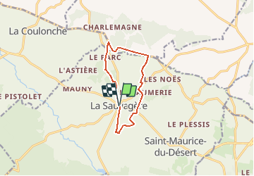
8 km | 9.5 km-effort
2h 10min
No
Trail Walking La Coulonche - La coulonche - Photo
Walking
Elisabeth Neveu

Walking

Very easy
La Coulonche, Normandy, Orne, France
3.7 km | 4.9 km-effort
1h 22min
Yes
Trail Walking Les Monts-d'Andaine - La Sauvagerie  - Photo
Walking
Elisabeth Neveu

Walking

Very easy
Les Monts-d'Andaine, Normandy, Orne, France
9.8 km | 11.6 km-effort
1h 31min
No
Trail Walking La Coulonche - UIA LF 28/11/2018 - Photo
Walking
toporient

Walking

Easy
La Coulonche, Normandy, Orne, France
7.5 km | 9.3 km-effort
2h 0min
Yes
Trail Walking La Coulonche - ballade nois de dieufit - Photo
Walking
ptimi

Walking

Easy
La Coulonche, Normandy, Orne, France
5.7 km | 6.8 km-effort
1h 59min
Yes
Trail Walking Unknown - Autour de Saint Michel des Andaines - Photo
Walking
tracegps

Walking

Medium
Unknown, Normandy, Orne, France
11.5 km | 13.2 km-effort
3h 30min
Yes
Trail Walking Unknown - En bordure de la Forêt des Andaines - Saint Maurice du Désert - Photo
Walking
tracegps

Walking

Medium
Unknown, Normandy, Orne, France
12.7 km | 14.9 km-effort
3h 30min
Yes
Trail Walking Les Monts-d'Andaine - la sauvagere - Photo
Walking
sitydomer

Walking

Difficult
Les Monts-d'Andaine, Normandy, Orne, France
11.6 km | 14.4 km-effort
2h 52min
Yes
Trail Bicycle tourism La Ferté-Macé - La Ferté Macé souligné sous ballon - Photo
Bicycle tourism
enoitna

Bicycle tourism

Difficult
La Ferté-Macé, Normandy, Orne, France
101 km | 116 km-effort
5h 21min
No


Close
My subscriptions